

Do the PebbleCreek Hikers Ever Get Lost?
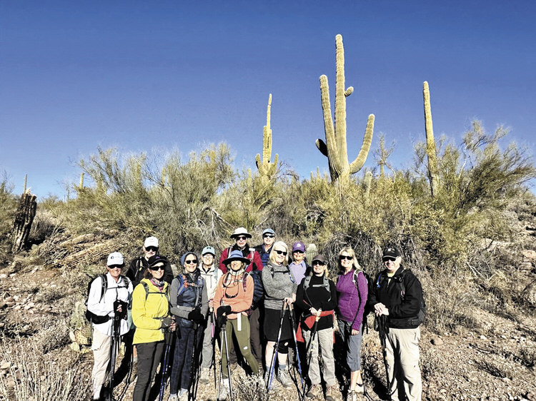
The photo here depicts an informal hike named Walkin’ Jim where the GAIA app helped with route finding. Hikers: Dorothy Sammartino, Dave Schuldt, Sandy Mednick, Terri de Mars, Nadine Eder, Laurie Rosenbloom, Gary Baker, John Chrusciel, Linda Schmillen, Freddie Wilson, Diane Chrusciel, Nancy Love, Tom Wick, and Jan Sherwood (photographer)
Jan Sherwood
Each month, photos and articles feature PebbleCreek hiking adventures; perhaps you wonder how we know where to hike and how we don’t get lost. For most hikes, there already are maps, parking lots, trail signs, and usually restrooms at trailheads. There are also more informal trails outside of established parks and recreation areas where we hike. For both established trails and more informal trails, each hike leader carries a cell phone with the GAIA app, or a similar GPS mapping system.
The GAIA app provides mapping navigation software that works with smart phones without the need for Wi-Fi or cell reception. For established areas the app already has trails ready to download. Before leading a new hike, the leader pre-hikes the trail using the app. When pre-hiking a new or an informal trail, the app records a new track, and leaves “breadcrumbs” or markers, enabling the hikers to find their way back. This new route is then uploaded to the hiking club’s website for other leaders to use. When hiking any trail again, the app shows our real time track in comparison with the established track. Join us on a hike and check out how GAIA helps us stay on track. Visit our website at pchikers.org.
Elephant Mountain Hike
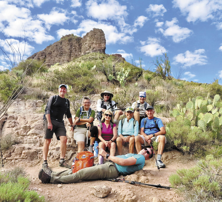
From left: Kerry Walsh, Diana Bedwell, Tom O’Reilly, Nancy Love, Marilyn Reynolds, Bill Halte, Clare Bangs (hike leader); lying: Coedy Hadden (photo by Ruth Bindler)
The PC Hikers offer a variety of hike distances and locations each week to appeal to a wide number of people eager to enjoy hiking and exploration. On a recent hike to Elephant Mountain in the Spur Cross Ranch Conservation Area near Cave Creek, hikers enjoyed a 10-mile hike with just under 2,000 feet elevation at a reasonable pace that enabled several hikers to meet this challenge. Spur Cross was a ranch that has become part of the Maricopa County Trail system, offering 2,154 acres that preserve trails and archeological sites. It encompasses spectacular rock outcroppings, cottonwood trees, a variety of cacti, and many animals and birds. Hohokam Indian petroglyphs and dwellings can be seen. Because of spring-fed streams, the area usually displays more green than other local parks; spring flowers are generally abundant. On the day of the hike shown here, the hikers forded a couple of streams by making their way across rocks.
Learn more about the variety of hikes offered by the club; visit the website at pchikers.org or come to a meeting on the third Monday of the month in the Palm Room at Eagle’s Nest Clubhouse.
Hikers Visit Dry Waterfall
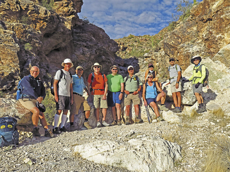
Left to right: Neal Wring, Mike Hevey, Ron Hoffman, Dana Thomas, Stacey Miller, Tom Wellman, Julie Walmsley, Kris Raczkiewicz, Mike Tansey, and Lynn Warren (photographer) pausing for a photo after a snack break at a scenic dry waterfall in the White Tanks
Lynn Warren
PebbleCreek residents are fortunate to have several nearby parks with great hiking trails. One of the best is White Tank Mountain Regional Park just west of Loop 303 and visible from PebbleCreek; this park has scenic trails which range from relatively flat and easy to steep and challenging. On Jan. 31, 10 “B” and “C” hikers enjoyed a scenic 11-mile loop that included a snack break at a scenic but rugged dry waterfall area with lots of exposed white granite that can be seen from quite a distance. The club tries to be flexible and, on this hike, several hikers wanted a shorter hike and the rest wanted a longer hike so the trails were selected to accommodate both. Why not join the hiking club and you, too, can enjoy interesting and scenic areas with a great group of people; visit the club website at pchikers.org for more information and photos.
Hiker Celebrates Another Milestone
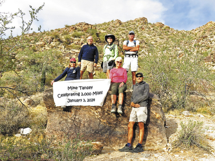
Left to right: Kris Raczkiewicz, Neal Wring, Lynn Warren (photographer), Jan Larsen, Clare Bangs and Mike Tansey celebrating a milestone along the Sonoran Loop (Competitive Loop) in White Tank Mountain Regional Park
Lynn Warren
Mike Tansey, originally a snowbird from St. Louis but now a full-time resident, joined the hiking club in 2018 and quickly established himself as a strong “B” hiker, and now has assumed a leadership role as club treasurer. Educated as an electrical engineer, Mike spent the majority of his career with MasterCard as an IT manager, but now enjoys the fruits of his labor by hiking frequently with the club (with a few timeouts to help his daughter, new granddaughter, and two sons with DIY projects). On Jan. 3, Mike checked off another club milestone and celebrated his achievement of 2,000 miles with five fellow “B” hikers on a familiar but scenic 11-mile hike along the Sonoran Loop in nearby White Tank Mountain Regional Park just west of Loop 303. Join the club and pursue your own milestones since the club hikes in many interesting areas around the valley; check the club website at pchikers.org for more information and photos.