
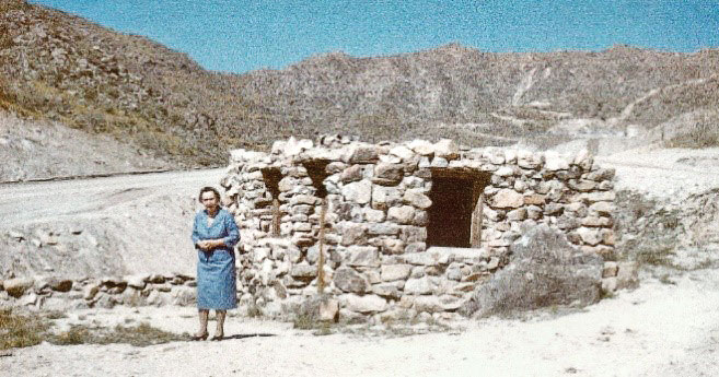
Florence Litchfield at cabin
Pam Katz
One of the best hiking destinations in the White Tank Mountains is the Litchfield Hunting Cabin, north of the Verrado development.
Paul Weeks Litchfield, an executive with Goodyear Tire and Rubber Company, came to Arizona in 1916 to find a suitable location to grow cotton for rubber tires to support the World War I effort. Goodyear purchased 5,000 acres in what is now Litchfield Park.
As part of his Arizona legacy, Litchfield constructed a hunting cabin dubbed the “Eagle’s Nest” in the White Tank Mountains near present day Verrado. The cabin was used to entertain friends and business associates who enjoyed hunting desert big horn sheep, deer and mountain lions. Litchfield also took company executives to the cabin by horseback for barbeques.
The 8 by 10 feet cabin was built with native stone and concrete mortar with an interior fireplace. The roof, which was built on the interior with wood beams and corrugated metal, no longer exits. Caterpillar purchased the property in 1945 and used it as a proving-ground for its equipment, creating the “scar” that runs parallel to a trail that was likely the route to the cabin.
Verrado developer DMB, Inc., who purchased the land in 1997, protected the structure by fencing it. In 2002, the site was dedicated as the Edith Litchfield Denny Memorial Park in memory of Paul Litchfield and his daughter Edith. The dedication plaque is now stored offsite for safekeeping. Viewing the remains invites both feelings of the solitude of the desert and images of festive parties held in the mountains.
Hiking to the cabin is best from the Lost Creek trailhead in Verrado. From I-10, take exit 120 north on Verrado Way approximately two miles to the traffic light at W. Lost Creek Drive. Turn left to the Lost Creek Trailhead parking at the end of the road. As you enter the trail, proceed to the first junction and go right (north) on the main trail. After approximately one mile, bear left through the boulder vehicle barrier to the Caterpillar Proving Ground scar, now known as Cat Hill. Take the Cat Hill trail to its top end and then bear right over to Tower Road. A short distance downhill on Tower Road is the cabin on the east side.
You can view the cabin and its fence on Google Maps aerial photos to help you find your way. It is about a four mile hike each way and a steady uphill climb. Do not try to access the cabin from the Victory section of Verrado as there is no parking and the area is posted as an active construction area.
Thanks to Karen Krause who is a White Tank Mountains Conservancy steward, Waddell historian and an author of The White Tank Mountains Field Guide for contributions to this article and to the Litchfield Park Historical Society and Museum for photographs.
Pam Katz is a steward with the White Tank Mountains Conservancy. For more information, contact WTMConservancy.org/volunteer.